Ice/mining axe
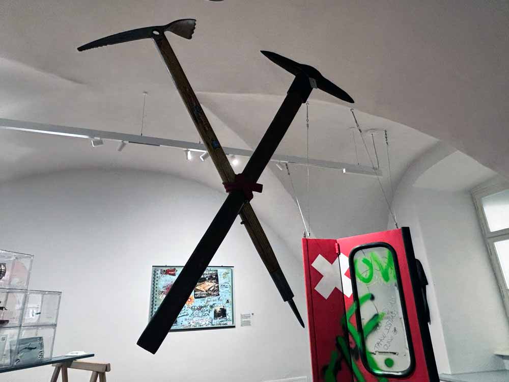
objects, 80 x 35 cm each
A mining(pick) and an ice axe. The latter is labeled Nanga Parbat (Naked Mountain), a Pakistani Himalayan mountain that has the greatest concentration of glaciers outside the polar regions, which decreased by 7% between 1934 and 2019. About 150 km from the peak in Chapurson Valley coal was discovered in 1996.
In 2022 coal contributed 27.6% of the global energy supplied while producing 43.7% of combustion emissions.
OpenAI. (2026). ChatGPT (GPT-5.6) [Large language model]. See prompts at the end
Parallel tool histories, coal’s carbon legacy and extractive landscapes at the glacier margin
Scope: The displayed mining pick and Stubai “Nanga Parbat” ice axe; tool genealogies from prehistory to the present; the crossed hammer-and-pick mining emblem; coal mining from the Industrial Revolution to July 2026; coal’s measured emissions and a transparent nominal atmospheric-CO2 attribution; major producing regions; and verified coal workings in glaciated terrain, with emphasis on Chapursan Valley and Svalbard. The report does not claim a precise date or provenance for the displayed pick, and it excludes unverified production totals for the Stubai model.
Abstract
The paired objects condense two contrary but historically connected ways of making mountains usable. The mining pick is an ancient breaking and extraction tool, attested in Neolithic Hallstatt by an antler pick dated to about 5000 BC; the modern ice axe emerged around the mid-nineteenth century by combining the alpenstock with a step-cutting axe, then evolved into metal and composite safety equipment. The Stubai Nanga Parbat model is securely documented by the 1970s, but its exact launch date, output and claimed link to the 1953 expedition remain unverified. The crossed mining emblem is not one trademark: it derives from a mallet and hand-held iron, was used in miners’ heraldry by the sixteenth century, and now circulates through coats of arms, signage, heritage institutions, DIN 21800 and Unicode. Coal enabled steam, iron, railways, electrification and modern industrial urbanisation while producing severe occupational, landscape, water, air-pollution and climate burdens. Coal accounts for about 46% of cumulative fossil CO2 emissions since 1850; a proportional carbon-budget calculation assigns it roughly 42 ppm of the atmospheric CO2 rise to 2023, with explicit sink assumptions. Chapursan and Svalbard show extraction literally entering glacial terrain, where warming now destabilises or floods the infrastructure it helped create.
Project links and cross-references: Exhibition objects · Archive of climate narratives · Project website. Related object reports: Glacier Express and Gaze (controlled access to mountain landscapes); Drill baby, drill! (fossil extraction and combustion); Container / Mount Scorluzzo (verified glacial archaeology); Edelweiss and Grossglockner objects (tourist spectacle and climate evidence); ELF timeline and No Sprawl (direct action against extractive and high-carbon infrastructures).
Contents
1. Object and label audit
2. Parallel histories of the mining pick and ice axe
3. The mining emblem: mallet, iron and crossed-tool genealogy
4. Coal since the Industrial Revolution: development and impact
5. Coal, cumulative emissions and atmospheric CO2
6. Global coal geography and the current re-expansion debate
7. Coal mines in glaciated terrain: Chapursan and Svalbard
8. Interpretive synthesis: tools of access, extraction and feedback
9. Numbered academic reference list
Appendix: User prompts
1. Object and label audit
The object description contains three different evidentiary layers: verified environmental data, an approximate geographical conjunction and an object-specific commercial history with significant gaps. Separating these layers prevents the display label from turning proximity or naming into false provenance.
Claim or object element | Source-critical assessment |
Displayed mining pick | Its exact maker, date and working context are not supplied. The report therefore treats it as a representative mining pick rather than assigning an unsupported provenance. |
Stubai “Nanga Parbat” ice axe | “NANGA PARBAT MADE IN AUSTRIA” and the Stubai mark are documented on museum examples. A 1970s Ellis Brigham catalogue securely places the wooden-shaft model on the market by that decade. Exact introduction date and total production remain undocumented. |
Claimed 1953 expedition connection | A resale listing makes this claim, but no manufacturer catalogue, expedition inventory or archival record located here confirms it. It is excluded from the factual genealogy. |
Nanga Parbat glacier change | A multi-source study of 63 glaciers found a 7% decrease in ice-covered area between 1934 and 2019. The wider Hindu Kush-Karakoram-Himalaya contains one of the largest non-polar concentrations of glacier ice; that superlative should not be assigned to Nanga Parbat alone. |
Chapursan coal discovery | Donnelly documents that villagers discovered coal and carbonaceous shale in 1996 while hunting and subsequently drove small adits into slopes beneath glaciers at the Reshit/Pamir mine. |
Distance between peak and coal area | The label’s “about 150 km” is best retained only as a rough regional statement. Depending on the exact mine and peak coordinates, the straight-line distance is closer to the broad range of about 150-180 km. |
2022 energy and emissions shares | The figures 27.6% of global energy supplied and 43.7% of fuel-combustion emissions reproduce an IEA-based accounting frame. They are definition-dependent and should be labelled as shares of total energy supply and fuel-combustion emissions, not as shares of all greenhouse gases. |
Academic source links: Glacier changes on the Nanga Parbat, 1856-2020 | Geological investigations at the Reshit/Pamir coal mine
References: [4], 117-150; [13], article 147321.
Primary / institutional evidence links: Scottish Mountain Heritage Collection: Stubai Nanga Parbat | IEA Greenhouse Gas Emissions from Energy Data Explorer
2. Parallel histories of the mining pick and ice axe
2.1 Mining pick: from antler and stone to industrial hand tool
The mining pick belongs to the oldest family of extractive implements. Prehistoric miners used antler, stone and wooden tools to break, pry and loosen mineral-bearing material. The Hallstatt High Valley provides the most important early comparison for the present object: a deer-antler pick found in 1838 in the Kaiser Josef Adit was radiocarbon-dated to roughly 7000 years ago, commonly expressed as about 5000 BC. Museum archaeologists describe it as a typical mining tool while warning that it does not, by itself, prove systematic underground salt mining at that early date; securely documented large-scale salt mining at Hallstatt belongs to later Bronze and Iron Age phases.
Metal did not simply replace the pick. Medieval and early-modern extraction relied on coordinated tool systems: pointed irons and wedges were struck with mallets; picks loosened softer rock and coal; hammers, chisels, baskets, windlasses and drainage devices organised the work. Agricola’s sixteenth-century De re metallica is crucial because it records these implements as parts of a technical and social system rather than as isolated shapes. Gunpowder blasting, drilling and mechanised cutting progressively displaced the pick from the main production face, but it persisted in trimming, scaling, prospecting, narrow workings, rescue and maintenance.
In nineteenth-century coal mining, the hand pick remained central even as steam drainage, rail haulage and ventilation enlarged the mine. Undercutting machines, compressed-air drills, continuous miners, longwall shearers and giant surface-mining excavators later transferred breaking force from the worker’s arm to powered machinery. The hand pick survived because it is portable, precise, cheap and independent of a power supply. Its emblematic life therefore outlasted its former productive centrality.
Academic source links: Early Metal Mining and Production | Kingdom of Salt: 7000 Years of Hallstatt | De re metallica
References: [1], books 5-6; [3], chapters 1-5; [11], passim.
Primary / institutional evidence links: Natural History Museum Vienna: early Hallstatt archaeology
2.2 Ice axe: alpenstock, step cutting and the modern piolet
The ice axe has a shorter genealogy because it answers a specialised problem: controlled travel on snow and glacier ice. Its principal predecessor was the alpenstock, a long wooden staff tipped with iron. On early alpine ascents, climbers also carried a separate small axe to cut steps. Illustrations associated with the 1786 first ascent of Mont Blanc show this functional division. Mountaineering histories and manufacturer records commonly date the fusion of staff and step-cutting head to around 1840. This is best understood as a design transition rather than the birth date of one universally agreed surviving “first” specimen.
Nineteenth-century axes had long wooden shafts and heads adapted for step cutting, balance and security. The classic head combined a pick with an adze; a spike at the lower end of the shaft assisted on snow. Through the twentieth century, shorter shafts, steel and aluminium construction, wrist leashes, improved picks and eventually curved ergonomic tools followed changes in climbing technique. Front-point crampons and steeper ice climbing shifted the axe from a walking staff and step-cutting tool towards anchoring, self-arrest and technical placement. Standards now distinguish general mountaineering axes from highly specialised ice tools.
Unlike the mining pick, whose working edge opens rock in order to remove material, the ice axe usually secures a body moving across a frozen surface. Yet both tools translate resistance into controlled access. Both also passed from local craft manufacture through industrial standardisation, brand identity, museum heritage and collectible afterlife.
Academic source links: The Summits of Modern Man | Nature’s Altars
References: [9], chapters 2-5; [16], chapters 1-3.
Primary / institutional evidence links: Grivel: ice axe history and technology | American Alpine Club: The Secret History of the Ice Axe
2.3 Stubai “Nanga Parbat”: product history and evidentiary limits
The uploaded Stubai report assembled the strongest accessible object-specific evidence. A Scottish Mountain Heritage Collection entry records a wooden-shaft Stubai Nanga Parbat in a 1970s Ellis Brigham catalogue and identifies the Austrian inscription and logo. Separate museum entries place metal-shaft and fibreglass “Nanga Parbat Extrem” versions within the broader 1960s-1970s transition from traditional wooden axes to all-metal and composite equipment.
This supports a cautious sequence: an established wooden model was commercially visible by the 1970s; later Extrem variants responded to changing materials and climbing technique; the name subsequently survived mainly in collections and the resale market. It does not establish a 1953 launch, a direct relationship to Hermann Buhl’s first ascent, a model-specific annual output or a complete list of export countries. The Nanga Parbat name should therefore be read as mountaineering branding that mobilises the prestige and danger of a Himalayan peak, not as proof that the displayed axe participated in an expedition there.
The attached research describes the wooden Nanga Parbat and Aschenbrenner models as among Stubai’s most successful classic axes, but this is a qualitative museum judgement, not a production count. Direct distribution evidence is strongest for Austria and the United Kingdom; other market traces are suggestive but incomplete.
Primary / institutional evidence links: SMHC: wooden-shaft Stubai Nanga Parbat | SMHC: metal-shaft Nanga Parbat Extrem | SMHC: fibreglass Nanga Parbat Extrem | Stubai company history
2.4 Comparative chronology
Period | Mining pick / extraction tool | Ice axe / mountain-access tool |
Neolithic to Bronze Age | Antler, stone and wooden picks break salt, flint, ore and rock; Hallstatt antler pick about 5000 BC. | No purpose-built ice axe. Staffs and simple spikes precede specialised glacier equipment. |
Medieval period | Iron picks, mallets, chisels and wedges support expanding European metal and salt mining. | Alpenstock used as a long spiked staff for snow and mountain travel. |
Sixteenth century | Agricola documents integrated systems of picks, hammers, irons, haulage, drainage and ventilation. The crossed-tool emblem is attested in miners’ heraldic culture by this period. | Separate staff and axe remain the functional components; no securely identified combined model. |
Late eighteenth to mid-nineteenth century | Coal output expands with steam drainage, coking, iron and transport. Hand picks remain central at the face. | 1786 Mont Blanc imagery shows alpenstock plus axe; combined piolet-type ice axe commonly dated to about 1840. |
Late nineteenth to early twentieth century | Mechanical coal cutters, drilling and powered haulage begin displacing hand breaking while picks persist for precision work. | Industrial manufacture standardises wooden shafts, forged heads, adzes and spikes; the axe becomes emblematic mountaineering equipment. |
Mid-to-late twentieth century | Continuous miners, longwall shearers and large surface machines dominate high-volume coal extraction. | Shorter metal/composite axes and technical ice tools respond to crampons, steep ice and modern safety practice; Stubai Nanga Parbat variants belong to this transition. |
Twenty-first century | The pick is marginal in high-volume production but remains in artisanal mining, maintenance, prospecting, rescue, heritage and visual identity. | Modern axes are regulated safety tools and branded sports equipment; classic models circulate as heritage objects and collectibles. |
References: [1], books 5-6; [3], passim; [9], chapters 2-5; [11], passim; [16], chapters 1-3.
3. The mining emblem: mallet, iron and crossed-tool genealogy
3.1 What the symbol depicts
The globally recognised mining sign is often called “hammer and pick”, but its historically precise German name is Schlägel und Eisen – mallet and iron. One hand holds a short striking hammer; the other holds a pointed iron or chisel against the rock. The iron’s handle projects beyond its head because the working piece could be removed and resharpened. Crossed in saltire, the pair compresses a two-handed labour process into one symmetrical mark.
This distinction matters for the displayed objects. The mining pick beside the ice axe resembles the pointed half of the emblem but is not identical to the separate hand-held iron shown in many Germanic versions. The image supplied with the prompt is a generic contemporary member of this symbol family rather than an identifiable proprietary logo.
3.2 Genealogy and earliest defensible dating
No single, securely documented “first use” of the crossed emblem could be established. Mining heritage institutions report that the tools were already used as miners’ arms or a mining sign in the sixteenth century. This is consistent with the early-modern consolidation of mining guilds, municipal heraldry, printed mining manuals and territorial administrations, but it should not be converted into a precise year. Agricola records the tools themselves in 1556; that does not prove that his illustrations originated the crossed emblem.
The emblem subsequently migrated across media: guild and occupational insignia; coats of arms of mining towns and regions; map keys identifying mines; mine entrances, lamps and grave markers; company and trade-union marks; socialist and labour iconography; geological and heritage tourism signage. In some central European cartographic conventions an inverted or modified crossed-tool mark indicates a closed or abandoned mine, although usage varies by map system.
3.3 Standardisation and present uses
Stage | Documented form and significance |
Early-modern heraldic use | Crossed hand tools represent the occupation, a mining jurisdiction or a town whose wealth derived from extraction. Exact first occurrence remains unresolved. |
Industrial and labour use | The emblem identifies collieries, miners’ associations, mutual-aid culture, uniforms, banners, memorials and municipal identity across European and later global mining regions. |
Technical standardisation | Germany’s DIN 21800 standard fixed a formal “Symbol mallet and iron” version. The current 1989 edition replaced the 1977 edition. |
Heritage and tourism | Museums, UNESCO mining landscapes, industrial heritage routes and reconstructed mines use the sign to convert former production sites into cultural destinations. |
Corporate and civic identity | Mining, engineering and commodity companies continue to adapt the crossed tools in logos; coats of arms preserve it after mines close. |
Digital circulation | Unicode encodes U+2692 as HAMMER AND PICK. Its digital life expands the sign beyond mining into generic labour, tools, geology, solidarity and themed social-media use. |
Academic source links: De re metallica
References: [1], books 5-6.
Primary / institutional evidence links: DIN 21800:1989-06 – Symbol mallet and iron | Unicode U+2692 – Hammer and Pick | Erzgebirge/Krušnohoří Mining Region – UNESCO | Industrial Monument Foundation: Schlägel und Eisen
4. Coal since the Industrial Revolution: development and impact
4.1 Developmental sequence
Coal was used long before industrialisation, but the eighteenth- and nineteenth-century conjunction of deep mining, coke-smelted iron, steam power, canals, railways and urban markets transformed its scale and systemic role. Coal did not act as an isolated cause. Economic historians disagree over how much Britain’s geological endowment directly raised national income, but they broadly agree that coal-powered technologies relaxed organic-energy constraints and became increasingly important after 1750. Proximity to coalfields was associated with faster urban growth once steam, iron and transport technologies could exploit it.
Period | Development | Historical consequence |
c. 1700-1800 | Coke begins replacing charcoal in iron smelting; steam engines pump water from deeper mines; canals and turnpikes extend markets. | Coal and iron become mutually reinforcing; deeper extraction supports more steam power, while steam enables deeper extraction. |
1800-1870 | Railways, steamships, mechanised factories and urban heating cause rapid demand growth; major coalfields organise industrial regions. | Mining settlements, labour movements, dangerous underground work and smoke pollution become defining features of industrial modernity. |
1870-1945 | Coal underpins steel, chemicals, imperial shipping, war industries and the expansion of electricity generation. Mechanical cutting and haulage spread unevenly. | Coal becomes a strategic national resource; states regulate labour, safety, output and transport while mines reshape landscapes and class politics. |
1945-1980 | Large thermal power stations, opencast mining and mechanised longwall systems raise productivity. Oil and gas displace coal in some transport and heating uses. | Advanced economies begin closing older pits; production and demand continue shifting geographically rather than disappearing. |
1980-2010 | Decline accelerates in Western Europe and parts of North America; China’s industrialisation and globalised steel and manufacturing drive enormous Asian growth. | Coal’s centre of gravity moves to Asia; surface mines and export corridors expand in Australia, Indonesia, South Africa and elsewhere. |
2010-2026 | Renewables grow rapidly, but coal demand and production remain near record levels. Security crises and electricity-demand growth cause temporary reversals or slower phase-outs. | The global system diverges: closures and just-transition policies coexist with new mines, extensions and record output in major Asian producers. |
Academic source links: Coal and the Industrial Revolution, 1700-1869 | Coal and the European Industrial Revolution | Energy and the English Industrial Revolution
References: [2], 39-72; [7], 1135-1149; [18], passim.
4.2 Environmental, health and social impacts
Impact domain | Documented mechanisms and consequences |
Occupational health and safety | Roof falls, explosions, fires, flooding and machinery injuries; chronic exposure to coal dust causes pneumoconiosis and other respiratory disease. Mechanisation reduces some tasks but introduces new hazards and does not eliminate dust. |
Land and settlement | Underground subsidence damages buildings and infrastructure. Surface and mountaintop mining remove soils and habitats, alter drainage and create spoil heaps, pits and resettlement zones. |
Water | Acid mine drainage mobilises sulphates and metals; mine dewatering changes groundwater; slurry and tailings contaminate streams; abandoned workings require long-term pumping and treatment. |
Air pollution | Combustion releases sulphur dioxide, nitrogen oxides, particulate matter, mercury and other toxics. Historic smoke transformed industrial cities; modern controls reduce but do not eliminate impacts. |
Waste | Coal ash and combustion residues require permanent storage and can contaminate groundwater. Methane escapes during mining and from abandoned workings. |
Climate | Coal has the highest CO2 intensity among major fossil fuels per unit of useful energy, especially lignite. Mining adds methane; combustion is the largest single fuel source of global energy-related CO2. |
Political economy | Coal created dense labour communities, unions and welfare institutions, but closures can produce concentrated unemployment, health burdens and fiscal decline. Just transition therefore concerns workers, public services, land repair and regional diversification, not only power-plant retirement. |
Academic source links: Inventing Pollution | Full cost accounting for the life cycle of coal | High-resolution coal-mine methane inventories
References: [5], 73-98; [15], article 00056; [17], passim.
5. Coal, cumulative emissions and atmospheric CO2
5.1 Measured emissions
Coal’s climate impact can be stated with high confidence at the level of emissions. The Global Carbon Budget 2024 estimates cumulative fossil CO2 emissions from 1850 through 2023 at about 490 ± 25 gigatonnes of carbon (GtC). Coal accounts for 46% of that total, ahead of oil (35%), gas (15%), cement carbonation sources (3%) and flaring (1%). Coal’s cumulative contribution is therefore about 225 GtC, equivalent to approximately 827 gigatonnes of CO2.
For recent annual flows, the IEA reports that fuel-combustion emissions were dominated by coal at roughly 44% in 2022, while the user’s label gives coal 27.6% of total energy supply and 43.7% of combustion emissions in the same accounting frame. In 2024, global energy-related CO2 reached 37.8 Gt and coal-related emissions rose again. These ratios demonstrate coal’s high carbon intensity, but they do not include all land-use emissions or every non-CO2 climate effect.
Academic source links: Global Carbon Budget 2024
References: [8], 965-1211, especially cumulative-emissions tables and fuel breakdowns.
Primary / institutional evidence links: IEA Greenhouse Gas Emissions from Energy Data Explorer | IEA CO2 Emissions in 2022 | IEA Global Energy Review 2025 – CO2 emissions
5.2 What “coal added to atmospheric ppm” can and cannot mean
Atmospheric instruments measure total CO2 concentration; they do not label individual molecules by fuel. A coal-specific concentration contribution therefore has to be calculated from an emissions budget and an explicit rule for sharing land and ocean uptake among sources. The following is a nominal proportional attribution, not a direct observation.
Step | Value and calculation |
1. Cumulative coal emissions, 1850-2023 | 46% × 490 GtC = about 225 GtC, or about 827 GtCO2. |
2. Total anthropogenic carbon used for sink sharing | Approximately 490 GtC fossil emissions plus about 225 GtC net land-use change = about 715 GtC. |
3. Observed atmospheric increase | From roughly 285 ppm around 1850 to 419.3 ppm in 2023: about 134 ppm. At about 2.12 GtC per ppm, this is roughly 284 GtC retained in the atmosphere. |
4. Long-period airborne fraction | 284 ÷ 715 ≈ 0.397, meaning about 40% of cumulative anthropogenic carbon remained airborne over this interval. |
5. Nominal coal-attributed concentration | 225 GtC × 0.397 ÷ 2.12 GtC per ppm ≈ 42 ppm. |
Interpretation | Under equal proportional sharing of sinks, coal is assigned about 42 ppm of the approximately 134 ppm atmospheric rise from 1850 to 2023 – roughly 31%. Different temporal sink models would alter the estimate. |
This calculation is transparent and reproducible, but it is not a claim that precisely 42 ppm of today’s air can be physically separated as “coal CO2”. Coal emissions occurred at different times and locations, ocean and land uptake are dynamic, and coal also affects climate through methane, aerosols and land disturbance. The robust conclusion is the cumulative emissions share: coal is the largest fossil contributor.
Academic source links: Global Carbon Budget 2024
References: [8], 965-1211.
6. Global coal geography and the current re-expansion debate
6.1 Main producing countries and coal-mining regions
Coal production is geographically concentrated but geologically diverse. China and India dominate consumption; China is also by far the largest producer. Indonesia and Australia are major exporters, while Russia, the United States, South Africa, Kazakhstan and Mongolia remain important producers. Germany is globally smaller but remains significant for lignite. The table identifies the principal coal regions rather than implying that national output is evenly distributed.
Country / group | Principal mining areas | Current position |
China | Shanxi; Inner Mongolia; Shaanxi; Xinjiang; Guizhou and other south-western fields. | Largest producer and consumer. Official output reached 4.83 billion tonnes in 2025. Expansion is primarily new capacity and consolidation, not simply reopening old pits. |
India | Odisha; Chhattisgarh; Jharkhand; Madhya Pradesh; Telangana; West Bengal. | Second-largest producer and consumer; state policy continues to increase domestic supply even as renewables expand. |
Indonesia | Kalimantan and Sumatra. | Large thermal-coal producer and exporter; exposed to Chinese and Indian demand and domestic power policy. |
Australia | Bowen and Surat basins; Hunter/Sydney basin; Galilee and other Queensland/New South Wales fields. | Major exporter of both metallurgical and thermal coal; project expansion remains politically contested. |
United States | Powder River Basin; Appalachian basins; Illinois Basin; Uinta and Gulf Coast fields. | Long-term structural decline, but 2025-2026 federal policy supports mine and plant life extension; output rose temporarily in 2025. |
Russia and Kazakhstan | Kuzbass, Kansk-Achinsk and Pechora; Ekibastuz and Karaganda. | Large Eurasian producers; rail capacity, sanctions, domestic power and Asian exports shape current development. |
South Africa | Mpumalanga / Central Basin and Waterberg. | Coal remains central to electricity and exports; ageing infrastructure and transition finance create tension. |
Mongolia | South Gobi, including Tavan Tolgoi. | Rapidly growing producer tied principally to overland exports to China. |
Germany and Poland | Rhineland, Lusatia and Central German lignite; Upper Silesia and Lublin. | European phase-out context, but lignite and hard-coal power persist during a managed transition. |
Primary / institutional evidence links: IEA Coal 2025 – supply | IEA Coal 2025 – demand | China National Bureau of Statistics: 2025 energy production
6.2 Global market position in 2025-2026
The latest completed IEA annual assessment reports that global coal demand reached a record approximately 8.85 billion tonnes in 2025 and expects only a gradual decline towards 2030. China and India together account for 71% of consumption. The 2026 Global Energy Review records a modest 0.4% increase in global coal demand in 2025, with China nearly flat. The central picture is therefore a plateau at historically extreme volume, not a completed global phase-out.
“Reopening” is an imprecise global description. In some places it means reactivating reserve power stations, extending a mine scheduled for closure or reopening a small number of pits. Elsewhere it means licensing new mines, expanding existing opencast operations or building new coal-power capacity. The following country cases distinguish those processes.
Primary / institutional evidence links: IEA Coal 2025 executive summary | IEA Global Energy Review 2026 – coal
6.3 United States: policy revival, limited physical reversal
Executive Order 14261 of 8 April 2025 directed federal agencies to “reinvigorate” domestic coal, accelerate leasing and permitting, identify coal resources on federal land and support coal use for electricity and emerging industrial demand. The Department of Energy subsequently announced programmes to modernise existing coal plants and keep selected units available. In 2026 the administration further linked the coal fleet to national defence and grid reliability.
The physical outcome is more modest than the rhetoric. U.S. coal production had fallen to about 512.5 million short tons in 2024, with 524 producing mines, and the long-term trajectory remains downward. Higher gas prices and policy support caused a temporary rise in coal generation, consumption and production in 2025, and some Appalachian mines reopened or extended operations. IEA forecasts nevertheless expect U.S. demand and production to decline towards 2030, although more slowly under current policy. The best description is a federally supported delay and partial rebound, not restoration of the twentieth-century coal economy.
Primary / institutional evidence links: Executive Order 14261 | U.S. Department of Energy coal-plant funding | U.S. EIA Annual Coal Report | IEA Coal 2025 – U.S. outlook
6.4 China: record production, expansion and simultaneous renewable growth
China’s coal sector is not principally a case of reopening abandoned mines. It is a case of record-scale production, consolidation, new capacity and strategic stockbuilding following energy-security concerns, especially after power shortages in 2021-2022. Official production reached 4.83 billion tonnes in 2025, up 1.2%. IEA data show China consumes more coal than the rest of the world combined and remains the decisive variable in global coal trends.
This expansion coexists with world-leading additions of solar, wind, storage and transmission. Coal power capacity can rise while utilisation rates flatten or fall, so capacity, generation, mine output and emissions must not be treated as interchangeable. The contradiction is structural: coal is maintained as industrial feedstock, regional employment base and dispatchable security resource while low-carbon generation grows at unprecedented speed.
Primary / institutional evidence links: China National Bureau of Statistics: 4.83 billion tonnes in 2025 | IEA Global Energy Review 2026 – coal | IEA Coal 2025 – supply
6.5 Germany: temporary power-station returns, no reopening of deep hard-coal mining
Germany’s domestic hard-coal mining ended in December 2018 after a long, subsidised phase-out. The 2020 Coal Phase-out Act requires coal-fired power generation to end no later than 2038; the Rhineland agreement advances RWE’s lignite exit to 2030. Domestic lignite opencast mining continues in the Rhineland, Lusatia and Central Germany during this transition.
After Russia’s full-scale invasion of Ukraine and the loss of Russian gas supply, Germany temporarily returned reserve hard-coal and lignite power units to the electricity market from 2022 through March 2024. This was a power-station measure, not a reopening of the deep hard-coal mines closed in 2018. Several temporary units were subsequently shut again. Germany therefore illustrates how an energy-security crisis can interrupt a phase-out schedule without reversing the underlying mine closure. Claims that the country “reopened coal mining” should distinguish continuing lignite extraction from temporary plant reactivation.
Academic source links: Lessons from Germany’s hard coal mining phase-out
References: [14], 963-979.
Primary / institutional evidence links: German Ministry for Economic Affairs: coal | German Coal Phase-out Act overview | Temporary return of reserve coal plants | Rhineland lignite phase-out by 2030
6.6 Other expansion and transition fronts
India remains the principal source of expected incremental demand through 2030 in the IEA outlook, while ASEAN growth is led by Indonesia and Viet Nam. Indonesia’s production and exports are sensitive to global trade and domestic obligations. Australia continues to approve, extend and contest large metallurgical and thermal-coal projects. Russia seeks Asian outlets under sanctions and transport constraints. South Africa’s coal system is simultaneously an electricity-security problem, an employment system and the focus of international just-transition finance. These cases reinforce the need to analyse mines, power stations, steelmaking and export markets separately.
Re-expansion is therefore uneven and temporally unstable. Record global tonnes can coexist with local collapse, and a national phase-out can coexist with imported coal. Current policy should be read as a contested field of security, employment, industrial strategy, climate commitments and regional inequality rather than as one linear return or decline.
Primary / institutional evidence links: IEA Coal 2025 – demand outlook | IEA Coal 2025 – supply outlook
7. Coal mines in glaciated terrain: Chapursan and Svalbard
7.1 Evidence categories
A global database of coal mines classified by distance to active glaciers does not exist. This report therefore avoids an exhaustive claim and uses three evidentiary categories: direct overlap, where mine infrastructure or workings intersect glacierised ground; hydrological interaction, where glacier meltwater enters or affects a mine; and regional proximity, where a coal settlement lies within a glaciated landscape but the specific working is not demonstrated to pass beneath ice.
Location | Evidence of glacier-mine relation | Status / significance |
Reshit / Pamir mine, Chapursan Valley, Pakistan | Donnelly describes small adits driven into steep slopes beneath glaciers after coal and carbonaceous shale were found in 1996. | Direct overlap. A rare published case in which high-altitude artisanal coal extraction is physically embedded in a glacierised Himalayan valley. |
Svea Nord and Lunckefjell, Svalbard | Mine areas, roads and restoration works occupied active glacial and periglacial terrain; a road crossed glacier ice between mining zones. | Direct overlap and post-mining restoration. Demonstrates the difficulty of removing industrial infrastructure while allowing active geomorphological processes to resume. |
Gruve 7 beneath Foxfonna, Svalbard | Glacier-groundwater pathways and mine fractures enabled major meltwater ingress; the mine flooded in July 2020 after exceptional melt. | Hydrological interaction. Warming directly disrupted the infrastructure of the fuel that contributes to warming. |
Barentsburg, Svalbard | The Russian-operated mine remains active within a heavily glaciated High Arctic landscape; direct overlap with a named glacier is less clearly documented in the sources used here. | Regional proximity and geopolitical continuity. Coal supports a Russian state presence even as Norwegian mining has ended. |
Pyramiden and Grumant, Svalbard | Former Soviet coal settlements stand in glaciated fjord landscapes and now function partly as heritage and tourism sites. | Regional proximity and afterlife. Extractive ruins become tourist scenery, documentation and geopolitical memory. |
Academic source links: Reshit/Pamir mine geological investigation | Restoring a Mining Landscape in the High Arctic | Glacier-groundwater coupling at Foxfonna
References: [4], 117-150; [6], article 87; [10], article 129894.
7.2 Chapursan Valley: high-altitude small-scale coal extraction
The Reshit or Pamir coal mine lies in the upper Chapursan Valley of north-west Pakistan, close to the Afghan frontier. Donnelly’s geological investigation reports that local villagers discovered coal and carbonaceous shale in 1996 while hunting. They then excavated a series of small adits with rudimentary methods into steep mountain slopes beneath glaciers. The mine has been described as among the world’s highest coal workings.
The case should not be enlarged into a major national coalfield. It is a remote, small-scale operation whose significance for this object lies in material proximity: the mountain surface traversed with an ice axe and the rock opened with a mining pick belong to one high-altitude terrain. The mine also complicates the idea of the glacier as untouched wilderness. It exists within local subsistence, border geography, transport difficulty and hazardous informal extraction.
Academic source links: Donnelly, Reshit/Pamir coal mine
References: [4], 117-150.
7.3 Svalbard: coal colony, sovereign presence and climate laboratory
Coal shaped Svalbard’s modern settlements, transport and sovereignty. Norwegian, Soviet/Russian and earlier international companies turned Arctic fjords into industrial enclaves. Longyearbyen, Svea, Barentsburg, Pyramiden and Grumant were not simply mining sites: they were company towns, ports, territorial presences and logistical systems constructed in permafrost and glacierised landscapes. As mining declined, science and tourism inherited many of these routes and structures.
The Norwegian system ended in stages. Svea Nord and Lunckefjell were closed, and between 2018 and 2024 Norway conducted an exceptionally large restoration programme that removed roads, housing, industrial facilities, an airport, landfills and quarries while preserving selected pre-1946 cultural remains. The project’s stated ambition was to return the area to a “near-natural” condition by enabling glacial, fluvial, coastal and periglacial processes to resume. The phrase is necessarily provisional: the restored landscape remains both industrial heritage and a rapidly warming geomorphological system.
Academic source links: Restoring a Mining Landscape in the High Arctic
References: [6], article 87.
Primary / institutional evidence links: Norwegian Institute for Nature Research: Svea restoration completed
7.4 Gruve 7 and Foxfonna: meltwater enters the mine
Gruve 7, east of Longyearbyen, extended beneath the Foxfonna ice cap. Glacier monitoring and hydrological research show how retreat and changing thermal conditions reorganise water movement between ice, bedrock, groundwater and mine fractures. In July 2020 exceptional meltwater flooded the workings, damaged equipment and interrupted production. The event is especially legible within this project because it is not a metaphor: climate-driven meltwater physically entered a coal mine.
Norway extended Gruve 7 in 2022 so that it could export industrial coal to Europe during the energy crisis. Store Norske ended production in July 2025 and completed final closure work in 2026, ending Norwegian coal mining on Svalbard. The sequence – climate flooding, wartime extension, closure and remediation – condenses the contradictory temporalities of emergency, energy security and decarbonisation.
Academic source links: Effects of glacier retreat upon glacier-groundwater coupling | Groundwater springs and methane after glacial retreat
References: [10], article 129894; [12], 597-604.
Primary / institutional evidence links: GlacierHub / Columbia Climate School: 2020 Gruve 7 flood | Store Norske: Gruve 7 closure | Norwegian government: extension to summer 2025
7.5 Barentsburg and the geopolitical remainder
After the Norwegian closure, the Russian state enterprise Trust Arktikugol continued limited mining in Barentsburg. Coal production is economically marginal compared with its historic scale, but the settlement’s value cannot be reduced to tonnes: it sustains employment, treaty rights, infrastructure and a Russian presence in a strategically important Arctic archipelago. Russian policy has also promoted tourism and research as partial successors to mining.
As of July 2026, Norwegian politicians have again proposed reopening coal mining on Svalbard for security and settlement reasons, but no new Norwegian mine had been established. This debate demonstrates that “reopening” may operate first as geopolitical rhetoric. The existing material reality is Norwegian closure and remediation alongside continuing Russian production in Barentsburg.
Primary / institutional evidence links: Svalbard Museum: Barentsburg | Store Norske: Gruve 7
8. Interpretive synthesis: tools of access, extraction and feedback
The mining pick and ice axe are visually parallel because both terminate in a pointed metal head attached to a shaft. Historically, however, they organise different relations to the mountain. The pick breaks rock so that matter can be removed and exchanged. The ice axe stabilises a body so that a dangerous frozen surface can be crossed, climbed and made available to expedition, sport, science or tourism. Placed together, they join extraction to access: before a mountain can be mined, mapped, photographed, visited or claimed, it must be made technically traversable.
The Nanga Parbat name intensifies this relation. It carries the ice axe from Austrian manufacture into Himalayan expedition mythology, while the nearby Chapursan case returns the branded mountain imaginary to local coal extraction beneath glaciers. The factual connection is not that this axe worked in that mine, but that the two tool types occupy one glacierised regional economy of movement, labour, risk and material removal.
Svalbard adds the feedback loop. Coal mining built settlements and sovereign infrastructures in the High Arctic; coal combustion contributed to atmospheric warming; meltwater then flooded Gruve 7 and rapid geomorphological change complicated the restoration of Svea and Lunckefjell. Former industrial routes now support scientific observation and tourism, converting extraction landscapes into sites where climate evidence is consumed panoramically. This links the object to Glacier Express, Gaze and the Grossglockner catastrophe-theatre reports without equating their scales or histories.
9. Numbered academic reference list
Chicago bibliography style. The numbered list contains scholarly books, critical editions and peer-reviewed journal articles. Current operational, legal, standards and company records are linked in the relevant sections as institutional evidence and are not included here.
3. Craddock, Paul T. Early Metal Mining and Production. Edinburgh: Edinburgh University Press, 1995.
Appendix: User prompts related to this report
Prompts are reproduced chronologically as a research-process record. Typographic normalisation is limited to spacing and quotation marks.
1. The next object’s description is:
object
A mining(pick) and an ice axe. The latter is labeled Nanga Parbat (Naked Mountain), a Pakistani Himalayan mountain that has the greatest concentration of glaciers outside the polar regions, which decreased by 7% between 1934 and 2019. About 150 km from the peak in Chapurson Valley coal was discovered in 1996.
In 2022 coal contributed 27.6% of the global energy supplied while producing 43.7% of combustion emissions.
1. review the attached reports and extract the information needed.
2. compile the parallel history of the two tools
3. research and present a short history of the globally used mining symbol/logo (its genealogy, its first usage, actual usages) https://encrypted-tbn0.gstatic.com/images?q=tbn:ANd9GcQA-yG9_8GJ87ihQDJYx1ZVpKxeh7i59xCqGNg2uqVlYA&s=10
4. research and summarise the historical development and impact of coal mining since the Industrial revolution and its proven nominal effects on CO2 levels. Present the geographical distribution of the main global coal mining areas and countries. Refer to the actual situation of reopening the mining industry (US, China, Germany, etc)
5. research on locations where coal mines are situated in the vicinity of glaciers, expand your research on Svalbard as well.