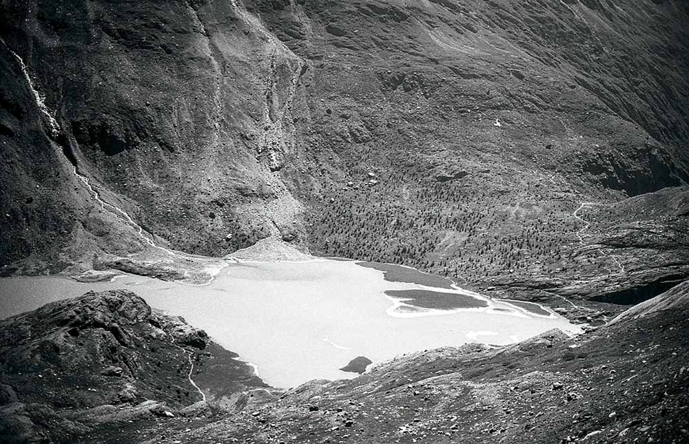
Portrait of a dying glacier
digital print on dibond (analogue negative scan), 73 x 47 cm
The analogue photo was taken in Austria at Kaiser-Franz-Josefs-Höhe at 2369 metres altitude, right under the peaks of Pasterze Glacier in the summer of 2025.
OpenAI. (2026). ChatGPT (GPT-5.6) [Large language model]. See prompts at the end
Dead Glaciers
A source-critical chronology of 48 independently auditable declassifications, residual ice patches and the problem of counting disappearance
Scope: Recent glaciers and small ice caps that have been authoritatively classified as gone, extinct, disappeared, no longer a glacier, or reduced to an ice patch; classification dates; latest independently verifiable residual ice surfaces; and the consequences of inconsistent definitions. The chronological register covers 1990–2026 and prioritises cases for which the requested fields can be audited. It excludes prehistoric disappearance, projections of future loss, and sites described only as endangered or almost disappeared.
Abstract
“Dead glacier” is a public and commemorative expression rather than a single universal scientific category. GLIMS began marking glaciers as extinct in 2023 and recorded 181 “gone” entries by August 2025, while explicitly describing that set as incomplete and leaving final decisions to regional experts. National inventories and field programmes use different combinations of area, flow, accumulation and fragmentation. This report therefore does not falsely present a complete world census. Instead, it supplies a chronological register of 48 named or separately mapped cases for which the classification date and present remnant can be independently audited. The register combines a complete 32-entry North Cascade field list, six Oregon Cascade cases and ten internationally prominent declassifications. In many cases ice remains after glacier status ends: Okjökull retained 0.07 km² of fragments in 2019, Pizolgletscher 0.0059 km² in 2023–24, and several Oregon and Washington glaciers persist as stagnant patches. The report also corrects the project’s earlier 2019 Triglav claim: Slovenia still officially monitors Triglav and Skuta as residual ice bodies, and no authoritative single declassification event was found.
Project links and cross-references: Project website · Exhibition pages · Supporting archive · Nations object and report
Method and source policy
The evidentiary core consists of peer-reviewed glacier inventories, regional field studies and scholarly analyses of extinction and memorialisation. GLIMS is treated as the principal global database framework, but not as a complete census. Official scientific agencies and university or research-project records are used where a declassification date or present residual area is not available in peer-reviewed literature. These are labelled as primary or institutional evidence and are not placed in the academic bibliography.
“Official classification” is not a globally standard administrative act. In this report the phrase “authoritative classification / determination” includes a national inventory decision, an official scientific-agency announcement, or a documented determination by the local experts responsible for the glacier record. “Latest residual surface” means the most recent published or institutionally documented area located during this research; it is not represented as a live measurement for 31 July 2026. Zero means that no ice was detected in the cited observation. “Not separately reported” is retained wherever the evidence does not support an invented number.
Academic source links: Tracking Extinct Glaciers in GLIMS | Glacier or Not? Nuance in Definitions of Vanishing Glaciers
References: [1], sections 2–3; [15], entire article.
Contents
1. What “dead” means: definitions and thresholds
2. Limits of a global chronology
3. Chronological register, 1990–2026
3.1 1990–2009
3.2 2014–2020
3.3 2021–2026
4. A case requiring qualification: Triglav and the 2019 claim
5. Interpretive synthesis: from glacier to ice patch, archive and memorial
6. Primary and institutional evidence links
7. Numbered academic reference list
Appendix: User prompts related to this report
1. What “dead” means: definitions and thresholds
A glacier can cease to count as a glacier before every particle of ice has melted. GLIMS defines an extinct glacier as one that has disappeared completely or has shrunk until local experts no longer consider it a glacier. A small remnant may persist as stagnant ice, debris-covered dead ice, a glacieret, a perennial snowfield or disconnected ice patches. Area alone is not decisive: evidence of present or past flow, an accumulation zone, crevassing, continuity and the resolution of the available imagery all affect classification.
Field | Documented information |
GLIMS database status | “gone” in the glacier_status / glac_stat field. |
Decision authority | Regional or local glacier experts; GLIMS follows their recommendation. |
Required extinction submission fields | GLIMS ID, estimated date or year of extinction, uncertainty and evidence source. |
Common but variable thresholds | Area cut-offs such as 0.01–0.05 km²; loss of measurable flow; fragmentation; or complete melt. |
Meaning of residual ice | Ice may remain materially present after the dynamic landform has been declassified. |
Academic source links: Tracking Extinct Glaciers in GLIMS | Disappearing Glaciers of the Oregon Cascades
References: [1], sections 2–3; [4], sections 2 and 5.
Primary / institutional evidence links: GLIMS extinct-glacier guide | GLIMS Glacier Database
2. Limits of a global chronology
No authoritative institution currently publishes a complete global table containing, for every extinct glacier, a name, an agreed declassification date and a current residual-ice area. GLIMS recorded 181 extinct entries as of August 2025, but its authors state that this is only a small subset of losses during the last fifty years. Some entries are unnamed polygons, regional inventories use different minimum areas, and the extinction field does not require a new measurement of surviving ice. Consequently, a table claiming to list “all dead glaciers” with current areas would combine incompatible criteria and invent missing values.
Field | Documented information |
GLIMS entries marked extinct, August 2025 | 181 |
GLIMS completeness assessment | Explicitly incomplete; many additional losses are known from the literature and regional experts. |
Conterminous USA inventory result | 52 previously identified glaciers could no longer be classified as glaciers by the inventory date. |
North Cascade field register used here | 32 current site records with a year lost and a 2022/23 residual-area field; Ice Worm is updated to 2024. |
Oregon Cascade register used here | Six disappeared glaciers when the earlier Palmer loss is included; five have mapped 2023 remnants. |
Auditable chronology supplied below | 48 named or separately mapped entries with transparent evidence and no fabricated residual areas. |
Academic source links: Tracking Extinct Glaciers in GLIMS | Inventory of Glaciers and Perennial Snowfields of the Conterminous USA | Disappearing Glaciers of the Oregon Cascades
References: [1], sections 3–3.1; [2], 4077–4104; [4], 1–6.
3. Chronological register, 1990–2026
The order follows the date of scientific determination or the best-supported year of loss, not the later date of a funeral, plaque, news report or journal publication. Where a source supplies only a year, no artificial day or month has been added. Two St. Patrick Bay ice caps are retained as separate mapped entities; the cited literature does not assign distinct proper names, so the letters A and B are editorial identifiers only.
3.1 1990–2009
1. Lewis Glacier
Authoritative classification / determination: 1990
Location: USA, Washington, North Cascade Range (Corteo Peak)
Latest verified residual ice surface / status: 0 km²; no mapped remnant in the 2022/23 field table.
2. Palmer Glacier
Authoritative classification / determination: By the 1990s; formally included in the 2026 assessment
Location: USA, Oregon, Mount Hood
Latest verified residual ice surface / status: Residual perennial snowfield / stagnant ice; no separate current area published in the six-glacier extinction assessment.
3. Camp Kiser
Authoritative classification / determination: 1993
Location: USA, Washington, North Cascade Range (Ptarmigan Ridge)
Latest verified residual ice surface / status: 0 km² in the 2022/23 table; only negligible relict ice reported visually by 2023.
4. David Glacier
Authoritative classification / determination: 1993
Location: USA, Washington, North Cascade Range
Latest verified residual ice surface / status: 0 km² in 2022/23.
5. Milk Lake Glacier
Authoritative classification / determination: 1993
Location: USA, Washington, North Cascade Range (Fire Mountain)
Latest verified residual ice surface / status: 0 km² in 2022/23.
6. Popocatépetl glacier system (including Ventorrillo and north-western tongues)
Authoritative classification / determination: Late 2000
Location: Mexico, Popocatépetl volcano, Puebla / State of Mexico
Latest verified residual ice surface / status: 0 km² as an active glacier system; static strips, blocks and séracs remained after extinction, but no complete present area was published.
7. Spider Glacier
Authoritative classification / determination: 2005
Location: USA, Washington, North Cascade Range (Chiwawa Peak)
Latest verified residual ice surface / status: 0.001 km² (0.1 ha) in 2022/23; disjointed perennial snowfields.
8. Arts Knoll
Authoritative classification / determination: 2005
Location: USA, Washington, North Cascade Range
Latest verified residual ice surface / status: 0.006 km² (0.6 ha) in 2022/23.
9. Lyall Glacier
Authoritative classification / determination: 2005
Location: USA, Washington, North Cascade Range (Frisco Peak)
Latest verified residual ice surface / status: 0.004 km² (0.4 ha) in 2022/23.
10. Happy Bunny Butte
Authoritative classification / determination: 2005
Location: USA, Washington, North Cascade Range
Latest verified residual ice surface / status: 0 km² in 2022/23.
11. Chacaltaya Glacier
Authoritative classification / determination: 2009
Location: Bolivia, La Paz Department, Cordillera Real
Latest verified residual ice surface / status: 0 km²; the former ski glacier had disappeared by 2009.
Academic source links: Inventory of Glaciers and Perennial Snowfields of the Conterminous USA | Unprecedented 21st-Century Glacier Loss on Mt. Hood | Chronicle of a Death Foretold: Popocatépetl | Chacaltaya case study
References: [2], 4077–4104; [5], 4517–4530; [6], 13–22; [7], 187–194.
Primary / institutional evidence links: North Cascade disappeared-glacier table
3.2 2014–2020
12. Okjökull
Authoritative classification / determination: 2014
Location: Iceland, western Iceland, Ok shield volcano / Borgarfjörður
Latest verified residual ice surface / status: 0.07 km² (7 ha) of residual fragments in 2019; each fragment was below 0.03 km². Memorial ceremony: 18 August 2019.
13. Mount Watson East
Authoritative classification / determination: 2015
Location: USA, Washington, North Cascade Range
Latest verified residual ice surface / status: 0.005 km² (0.5 ha) in 2022/23.
14. Columbia Peak
Authoritative classification / determination: 2015
Location: USA, Washington, North Cascade Range
Latest verified residual ice surface / status: 0.021 km² (2.1 ha) in 2022/23.
15. Lynch Gap
Authoritative classification / determination: 2015
Location: USA, Washington, North Cascade Range
Latest verified residual ice surface / status: 0.005 km² (0.5 ha) in 2022/23.
16. West Lynch
Authoritative classification / determination: 2015
Location: USA, Washington, North Cascade Range
Latest verified residual ice surface / status: 0 km² in 2022/23.
17. Diptop
Authoritative classification / determination: 2015
Location: USA, Washington, North Cascade Range
Latest verified residual ice surface / status: 0.008 km² (0.8 ha) in 2022/23.
18. East Daniels
Authoritative classification / determination: 2015
Location: USA, Washington, North Cascade Range
Latest verified residual ice surface / status: 0 km² in 2022/23.
19. Snow Creek Glacier, GLIMS G239181E47474N
Authoritative classification / determination: 2015
Location: USA, Washington, North Cascade Range
Latest verified residual ice surface / status: 0.030 km² (3.0 ha) in 2022/23.
20. Snow Creek Glacier, GLIMS G239186E47472N
Authoritative classification / determination: 2015
Location: USA, Washington, North Cascade Range
Latest verified residual ice surface / status: 0.010 km² (1.0 ha) in 2022/23.
21. East White River
Authoritative classification / determination: 2015
Location: USA, Washington, North Cascade Range
Latest verified residual ice surface / status: 0.008 km² (0.8 ha) in 2022/23.
22. Table Mountain
Authoritative classification / determination: 2015
Location: USA, Washington, North Cascade Range
Latest verified residual ice surface / status: 0.008 km² (0.8 ha) in 2022/23; fragmented inactive segments.
23. Coleman Pinnacle
Authoritative classification / determination: 2018
Location: USA, Washington, North Cascade Range
Latest verified residual ice surface / status: 0.018 km² (1.8 ha) in 2022/23.
24. Ayoloco Glacier
Authoritative classification / determination: Disappeared in 2018; declared by UNAM on 22 April 2021
Location: Mexico, Iztaccíhuatl volcano, State of Mexico / Puebla
Latest verified residual ice surface / status: 0 km²; plaque records disappearance in 2018.
25. Lathrop Glacier
Authoritative classification / determination: Listed gone in the 2018 inventory; field-confirmed in 2020
Location: USA, Oregon, Mount Thielsen
Latest verified residual ice surface / status: 0 km² in the 2023–24 Oregon assessment.
26. Thayer Glacier
Authoritative classification / determination: Listed gone in the 2018 inventory; field-confirmed as stagnant debris-covered ice in 2023–24
Location: USA, Oregon, North Sister
Latest verified residual ice surface / status: 0.022 km² (2.2 ha) of debris-covered stagnant ice in 2023.
27. Clark Glacier
Authoritative classification / determination: Field determination in 2020; published classification in 2026
Location: USA, Oregon, South Sister
Latest verified residual ice surface / status: 0.025 km² (2.5 ha) of disconnected remnant patches in 2023.
28. Glisan Glacier
Authoritative classification / determination: Stagnated by 2020; published classification in 2026
Location: USA, Oregon, Mount Hood
Latest verified residual ice surface / status: 0.009 km² (0.9 ha) of discontinuous ice in 2023.
29. St. Patrick Bay ice cap A (western mapped entity)
Authoritative classification / determination: 14 July 2020 satellite confirmation
Location: Canada, Nunavut, northeastern Ellesmere Island, Hazen Plateau
Latest verified residual ice surface / status: 0 km²; absent from the 14 July 2020 ASTER image.
30. St. Patrick Bay ice cap B (eastern mapped entity)
Authoritative classification / determination: 14 July 2020 satellite confirmation
Location: Canada, Nunavut, northeastern Ellesmere Island, Hazen Plateau
Latest verified residual ice surface / status: 0 km²; absent from the 14 July 2020 ASTER image.
Academic source links: Iceland national glacier inventory to 2019 | The Okjökull Memorial and Geohuman Relations | Disappearing Glaciers of the Oregon Cascades | Rapid Wastage of the Hazen Plateau Ice Caps
References: [4], 1–6; [8], 1–34; [9], 30–45; [10], 169–177.
Primary / institutional evidence links: North Cascade disappeared-glacier table | UNAM declaration of Ayoloco’s disappearance | NSIDC confirmation of the St. Patrick Bay ice-cap losses
3.3 2021–2026
31. Mixup Peak
Authoritative classification / determination: 2021
Location: USA, Washington, North Cascade Range
Latest verified residual ice surface / status: 0.016 km² (1.6 ha) in 2022/23.
32. The Triplets
Authoritative classification / determination: 2021
Location: USA, Washington, North Cascade Range
Latest verified residual ice surface / status: 0.018 km² (1.8 ha) in 2022/23.
33. Cascade Peak
Authoritative classification / determination: 2021
Location: USA, Washington, North Cascade Range
Latest verified residual ice surface / status: 0.015 km² (1.5 ha) in 2022/23.
34. Forbidden Peak South
Authoritative classification / determination: 2021
Location: USA, Washington, North Cascade Range
Latest verified residual ice surface / status: 0.030 km² (3.0 ha) in 2022/23.
35. Pizolgletscher
Authoritative classification / determination: End of summer 2022
Location: Switzerland, Canton of St Gallen, Pizol massif
Latest verified residual ice surface / status: 0.0059 km² (0.59 ha) in 2023–24; approximately 25,000 m³ of ice and mean thickness around 4 m in 2024.
36. Südlicher Schneeferner
Authoritative classification / determination: 26 September 2022
Location: Germany, Bavaria, Zugspitze / Wetterstein Alps
Latest verified residual ice surface / status: <0.01 km² (<1 ha) in September 2022; thickness mostly below 2 m and maximum below 6 m; classified as dead ice.
37. Kyes Peak
Authoritative classification / determination: 2022
Location: USA, Washington, North Cascade Range
Latest verified residual ice surface / status: 0.044 km² (4.4 ha) in 2022/23.
38. Hinman Glacier
Authoritative classification / determination: 2022
Location: USA, Washington, North Cascade Range
Latest verified residual ice surface / status: 0.034 km² (3.4 ha) total in the 2022/23 table; individual small remnants around 0.01 km² were also described.
39. Lemah
Authoritative classification / determination: 2022
Location: USA, Washington, North Cascade Range
Latest verified residual ice surface / status: 0.010 km² (1.0 ha) in 2022/23.
40. Stuart West
Authoritative classification / determination: 2022
Location: USA, Washington, North Cascade Range
Latest verified residual ice surface / status: 0.016 km² (1.6 ha) in 2022/23.
41. New Morning Peak
Authoritative classification / determination: 2022
Location: USA, Washington, North Cascade Range
Latest verified residual ice surface / status: 0.024 km² (2.4 ha) in 2022/23.
42. Black Peak
Authoritative classification / determination: 2022
Location: USA, Washington, North Cascade Range
Latest verified residual ice surface / status: 0.015 km² (1.5 ha) in 2022/23.
43. Arriva Peak
Authoritative classification / determination: 2022
Location: USA, Washington, North Cascade Range
Latest verified residual ice surface / status: 0.030 km² (3.0 ha) in 2022/23.
44. Milk Creek Glacier
Authoritative classification / determination: Field classification in 2023; published in 2026
Location: USA, Oregon, Mount Jefferson
Latest verified residual ice surface / status: 0.006 km² (0.6 ha) of stagnant ice in 2023.
45. Ice Worm Glacier
Authoritative classification / determination: 2023
Location: USA, Washington, North Cascade Range, Mount Daniel–Mount Hinman complex
Latest verified residual ice surface / status: 0.030 km² (3.0 ha) in 2024; debris-covered, thinned and without glacier flow.
46. West Sulphide
Authoritative classification / determination: 2023
Location: USA, Washington, North Cascade Range
Latest verified residual ice surface / status: 0.050 km² (5.0 ha) in 2022/23.
47. Humboldt / La Corona
Authoritative classification / determination: May 2024 public scientific reclassification
Location: Venezuela, Mérida State, Sierra Nevada de Mérida, Pico Humboldt
Latest verified residual ice surface / status: Approximately 0.020 km² (2 ha) in March 2024; static remnant reclassified as an ice field.
48. Cerros de la Plaza Glacier
Authoritative classification / determination: IDEAM announcement, March 2026
Location: Colombia, Boyacá, Sierra Nevada del Cocuy–Güicán, El Cocuy National Natural Park
Latest verified residual ice surface / status: 0 km²; Sentinel-2 imagery of 28 February 2026 showed no remaining glacier ice.
Academic source links: The Loss of Ice Worm Glacier | Continuous Monitoring of a Glacier’s Extinction | Disappearing Glaciers of the Oregon Cascades | The History and Disappearance of Glaciers in Venezuela | The End of the Eternal Snows
References: [3], article 432; [4], 1–6; [11], article e27; [12], 85–124; [13], 563–581.
Primary / institutional evidence links: North Cascade disappeared-glacier table | Bavarian Academy: Südlicher Schneeferner declassification | NASA/JPL: Humboldt Glacier, Venezuela | Copernicus: Cerros de la Plaza disappearance
4. A case requiring qualification: Triglav and the 2019 claim
The project’s earlier Nations text stated that Slovenia was the first nation to lose all its glaciers and that Triglav Glacier was declared gone in 2019. The best available evidence does not support a single official 2019 declassification. Slovenian monitoring continues to refer to the Triglav and Skuta glaciers, while glaciological writing alternates among glacier, glacieret, remnant and ice patch because the bodies are extremely small and their flow is difficult or impossible to demonstrate. In March 2025 the Slovenian government reported that Triglav’s residual ice covered 0.2 hectares (0.002 km²) in 2024, but did not announce that it had ceased to exist.
Field | Documented information |
Earlier project formulation | “Triglav Glacier has been declared gone in 2019; Slovenia is the first nation to have lost all of its glaciers.” |
Source-critical assessment | No authoritative single 2019 declaration located; official monitoring still records two residual ice bodies. |
Latest official Triglav surface located | 0.002 km² (0.2 ha) in 2024, reported 20 March 2025. |
Recommended wording | Slovenia retains two extremely small perennial ice remnants whose status as conventional flowing glaciers is contested. |
Editorial placement | Do not add Triglav to the chronological extinction register until a clearly sourced declassification is identified. |
Academic source links: Documentation of Triglav Glacier Using Non-Metric Panoramic Images | Glacier or Not? Nuance in Definitions of Vanishing Glaciers
References: [14], 80–86; [15], entire article.
Primary / institutional evidence links: Government of Slovenia: 2024 Triglav Glacier area | Nations object page (claim reviewed here)
5. Interpretive synthesis: from glacier to ice patch, archive and memorial
The classification of a glacier’s death is an act of measurement and naming imposed on a materially continuous process. A glacier can lose dynamic flow, administrative status and cultural identity at different times. This is why Okjökull’s scientific declassification in 2014, its public funeral in 2019 and the persistence of residual ice in the same year are not contradictory. Likewise, the Pizol memorial ceremony preceded the glacier’s formal 2022 loss of status. The date of death is therefore not simply discovered; it is produced by an inventory threshold, expert judgement and a public narrative.
Within The Sunshine Find, these cases connect glacier monitoring to catastrophe theatre and last-chance tourism. Panoramic routes and observation infrastructures invite visitors to witness retreat as spectacle, while satellite images, repeat photography and inventories convert disappearance into legible evidence. This relation should be read beside the Glacier Express and the Grossglockner/Pasterze objects, where scenic mobility and branded alpine experience coexist with visible ice loss.
Residual ice also marks a transition from living geomorphological agent to material archive. The ice patch may no longer flow, yet it can preserve biological matter, artefacts and historical traces relevant to the Necklace/Ötzi and Container/Mount Scorluzzo reports. In that sense, the “dead glacier” is not empty: it is a contested remainder whose scientific, national and commemorative meanings continue after declassification. The corrected Triglav case is especially important for Nations, demonstrating that national mourning can outpace the evidentiary threshold. These public forms prepare the project’s later movement towards climate politics and direct action.
Academic source links: The Okjökull Memorial and Geohuman Relations | Continuous Monitoring of a Glacier’s Extinction | Tracking Extinct Glaciers in GLIMS
References: [1], entire article; [9], 30–45; [11], entire article.
6. Primary and institutional evidence links
These sources document database status, field determinations, official announcements or the latest available residual areas. They are not presented as peer-reviewed scholarship.
1. GLIMS extinct-glacier guide. Definition, local-expert rule and submission guidance.
2. GLIMS Glacier Database. Global database access and extinct-glacier layer.
3. North Cascade Glacier Climate Project: Washington glaciers lost since 1984. Year-lost and 2022/23 residual-area table used for 32 records.
4. UNAM: Ayoloco declaration. University-led declaration and 2018 disappearance date.
5. NSIDC: St. Patrick Bay ice caps. ASTER confirmation that both mapped caps were absent on 14 July 2020.
6. Bavarian Academy of Sciences: Südlicher Schneeferner. Official loss of glacier status on 26 September 2022.
7. NASA/JPL: Humboldt Glacier. March 2024 imagery and approximately two-hectare remnant.
8. Copernicus: Cerros de la Plaza. IDEAM March 2026 announcement and Sentinel-2 chronology.
9. Government of Slovenia: Triglav residual ice. Official 2025 report giving the glacier area as 0.2 ha in 2024, used to qualify the 2019 claim.
7. Numbered academic reference list
Chicago bibliography style. The list contains only verified peer-reviewed scholarship.
1. Raup, Bruce H., Liss Marie Andreassen, Dominic Boyer, Cymene Howe, Mauri Pelto, and Antoine Rabatel. “Tracking Extinct Glaciers in GLIMS.” Annals of Glaciology 66 (2025): e35. Persistent link
2. Fountain, Andrew G., Bryce Glenn, and Christopher McNeil. “Inventory of Glaciers and Perennial Snowfields of the Conterminous USA.” Earth System Science Data 15 (2023): 4077–4104. Persistent link
3. Pelto, Mauri S., and Jill Pelto. “The Loss of Ice Worm Glacier, North Cascade Range, Washington USA.” Water 17, no. 3 (2025): 432. Persistent link
4. Carlson, Anders Eskil, Nicolas Bakken-French, Megan Thayne, Sam Pappas, Daniela Molnar, and Dylan Rood. “Disappearing Glaciers of the Oregon Cascades, USA.” Annals of Glaciology 66 (2025): e1, 1–6. Persistent link
5. Bakken-French, Nicolas, Stephen J. Boyer, B. Clay Southworth, Megan Thayne, Dylan H. Rood, and Anders E. Carlson. “Unprecedented 21st Century Glacier Loss on Mt. Hood, Oregon, USA.” The Cryosphere 18 (2024): 4517–4530. Persistent link
6. Delgado Granados, Hugo, P. Julio Miranda, Christoph Huggel, S. Ortega del Valle, and M. A. Alatorre Ibargüengoitia. “Chronicle of a Death Foretold: Extinction of the Small-Size Tropical Glaciers of Popocatépetl Volcano (Mexico).” Global and Planetary Change 56, nos. 1–2 (2007): 13–22. Persistent link
7. Ramírez, Edson, et al. “Small Glaciers Disappearing in the Tropical Andes: A Case-Study in Bolivia: Glaciar Chacaltaya (16° S).” Journal of Glaciology 47, no. 157 (2001): 187–194. Persistent link
8. Hannesdóttir, Hrafnhildur, Oddur Sigurðsson, Ragnar H. Þrastarson, Snævarr Guðmundsson, Joaquín M. C. Belart, Finnur Pálsson, Eyjólfur Magnússon, Skúli Víkingsson, Ingibjörg Kaldal, and Tómas Jóhannesson. “A National Glacier Inventory and Variations in Glacier Extent in Iceland from the Little Ice Age Maximum to 2019.” Jökull 70 (2020): 1–34. Persistent link
9. Howe, Cymene, and Dominic Boyer. “The Okjökull Memorial and Geohuman Relations.” Social Anthropology / Anthropologie sociale 32, no. 1 (2024): 30–45. Persistent link
10. Serreze, Mark C., Bruce H. Raup, Carsten Braun, Douglas R. Hardy, and Raymond S. Bradley. “Rapid Wastage of the Hazen Plateau Ice Caps, Northeastern Ellesmere Island, Nunavut, Canada.” The Cryosphere 11 (2017): 169–177. Persistent link
11. Huss, Matthias, Mauro Fischer, Andreas Linsbauer, and Andreas Bauder. “Continuous Monitoring of a Glacier’s Extinction.” Annals of Glaciology 66 (2025): e27. Persistent link
12. Braun, Carsten, and Maximiliano Bezada. “The History and Disappearance of Glaciers in Venezuela.” Journal of Latin American Geography 12, no. 2 (2013): 85–124. Persistent link
13. Ramírez, N., A. Melfo, L. M. Resler, and L. D. Llambí. “The End of the Eternal Snows: Integrative Mapping of 100 Years of Glacier Retreat in the Venezuelan Andes.” Arctic, Antarctic, and Alpine Research 52 (2020): 563–581. Persistent link
14. Triglav-Čekada, Mihaela, and Matej Gabrovec. “Documentation of Triglav Glacier, Slovenia, Using Non-Metric Panoramic Images.” Annals of Glaciology 54, no. 62 (2013): 80–86. Persistent link
15. Pope, Allen. “Glacier or Not? The Importance of Nuance in Definitions of Vanishing Glaciers.” Annals of Glaciology 66 (2025): e32, 1–8. Persistent link
Appendix: User prompts related to this report
Prompts are reproduced chronologically as a research-process record. Original spelling is preserved.
1. Make a research on ‘dead glaciers’.
2. compile a numbered chronological list of all the galciers that have been classified as gone:
a) name of the glacier
b) location (country, region)
c) date of official classification
d) its actual surface as an ice patch
3. create an RTF according to standars and criteria